Four Centuries on One Hilltop
The Full Story
The property at 211 South Main Street is not a conventional house on a conventional lot. It is the surviving core of a historic landscape—a hilltop that has been farmed, inherited, consolidated into a private estate, crossed by a railroad, registered with the Massachusetts Land Court, subdivided around, and built upon for close to two hundred years.
Understanding the castle requires understanding its land. The modern neighborhood adapted to this property, not the other way around. Houses were built around the estate. Streets followed routes that already existed. Rights that farmers established in the 1830s still run with the land today.
This is that story.
The Homestead Era
Long before addresses or streets existed, this part of Cohasset was open agricultural land. The earliest documented families associated with the property—the Lothrops and the Pratts—worked the land as a shared homestead: pasture, orchard, dwelling house, farm lanes, and a communal water source.
Ownership was family-based, not parcel-based. When land was divided among heirs, they still needed to cross each other’s fields, still shared the well, still used the common paths. These everyday arrangements would later harden into permanent legal rights—the easements and access ways that still affect the property today.
The Pratt Farmstead
Through the mid-nineteenth century, the Pratt family controlled the property as a multi-party farmstead. Deeds from this era show transfers among heirs, undivided interests, and continued shared occupation. No property lines existed the way they do today. The land functioned as a single working unit, and the “driveway” and “well rights” we see on modern surveys were simply daily life.
Consolidation Into an Estate
In 1866, the land was acquired by Morgan B. Stetson, who assembled multiple farm portions into one larger tract. This marked a transition that was happening across Cohasset: the shift from working farm to private estate. The internal circulation—paths, access routes, water infrastructure—remained in place even as the land’s purpose changed.
The Railroad Crosses the Land
A railroad corridor crossed the property in the 1870s, and the deed that allowed it included a critical reservation: the right for the remaining land to cross the tracks, forever.
That single clause forced the land to stay connected. Even after later subdivision, access routes could not disappear and interior parcels could not be isolated. This is the earliest modern encumbrance still affecting the property—a legal mark laid down more than 150 years ago that shapes how the land works today.
Construction
Sometime between 1920 and 1930—the exact date remains a question for the assessor’s records to answer definitively—a castle rose on the hilltop.
The building is Tudor Revival in style, part of an architectural movement that swept American suburbs and estates in the early twentieth century. Tudor Revival drew on late-medieval English precedents: steeply pitched roofs, prominent chimneys, stone or brick construction, and dramatic interior halls with oversized fireplaces. In the Boston area, Tudor homes became signatures of wealth and taste in communities like Brookline, Newton, Wellesley, and the South Shore.
Cohasset had its own tradition of grand estates. As the town’s fishing industry declined in the 1870s and 1880s, wealthy Boston businessmen and industrialists discovered its cool ocean breezes and dramatic coastline. They built summer homes that became year-round residences—Tudor mansions, colonial revivals, shingle-style cottages—along the coast and on the town’s hills. Colonel Albert Pope, the bicycle and automobile pioneer, built a Tudor estate called Lyndermere just a few miles away. The castle at 211 South Main was part of this wave.
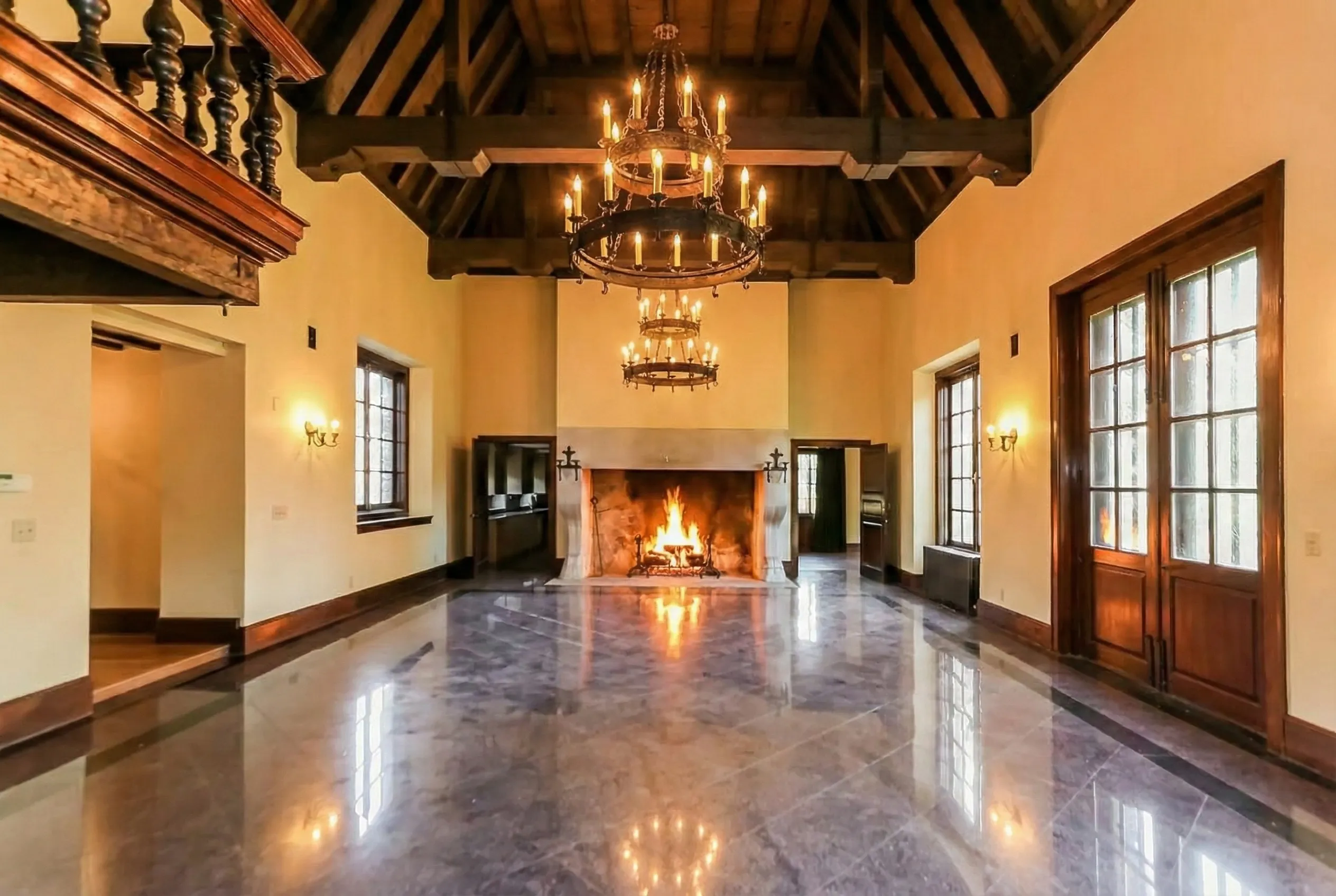
What they built was substantial: approximately 8,000 square feet of stone and slate, with a grand hall, marble floors, high ceilings, mahogany doors, a library with a balcony overlooking the great room, and seven or eight fireplaces (accounts vary). A detached three-car garage with a loft served as the carriage house. Stone patios and walls integrated the building into its hilltop site. A private irrigation system fed the grounds.
The castle sits at the end of a long, unpaved drive that ascends from South Main Street. It is not visible from the road. You approach it gradually—through trees, up the hill, until the stone facade appears above you. It is, by design, a reveal.
The 1925 Plan and Modern Development
In 1925, a formal subdivision plan (Plan 5820-B, prepared by surveyor Walter B. Foster) created the modern lots surrounding the estate. But the plan did not create the shared access ways—it mapped routes that already existed. Houses were built around the estate, not the estate carved into houses.
This is why the property’s boundaries look unusual on a modern map, why access crosses multiple parcels, and why the estate parcel remained large while the surrounding lots are standard residential size. The modern neighborhood grew up around a landscape that was already in place.
The Spanish Well
Historic farmsteads relied on a central water source. Evidence from the property’s deed history suggests a well—sometimes referred to locally as the “Spanish Well”—that predates the subdivision, served multiple structures, and remained after parcels were created. The right to use or maintain it follows the land itself. Even if modern plumbing has replaced its practical function, the legal right and the physical structure may still persist somewhere on the grounds.
It is one of many details we hope to rediscover during restoration.
Five Layers
What makes this property unusual—and what makes it occasionally confusing—is that five distinct historical layers overlap on a single parcel:
Agricultural Shared Use
The oldest layer, from farm-era path and water rights.
Estate Layout
From the Stetson consolidation and the castle’s construction.
Railroad Crossing Reservation
A permanent circulation right from the 1870s.
Registered Land Preservation
The Land Court froze all existing rights in place.
Modern Zoning
The most recent, and actually the least powerful layer.
Most residential properties have only the last one. This property has all five simultaneously. That is why it feels complicated—and why it rewards careful study.
Two hundred years at a glance
Document Archive
As our research continues, we are building an archive of the primary documents that tell this property’s story—deeds, plans, surveys, assessor records, and maps spanning nearly two centuries.
Coming soon
Coming soon
Coming soon
Coming soon